
Beneath the surface of the equatorial Pacific, the water runs more than 10 °C above its usual temperature. That accumulated heat feeds an El Niño event which, according to NOAA, the United States’ oceanic and atmospheric agency, has a 75% probability of exceeding all those recorded since 1950 between October and December.
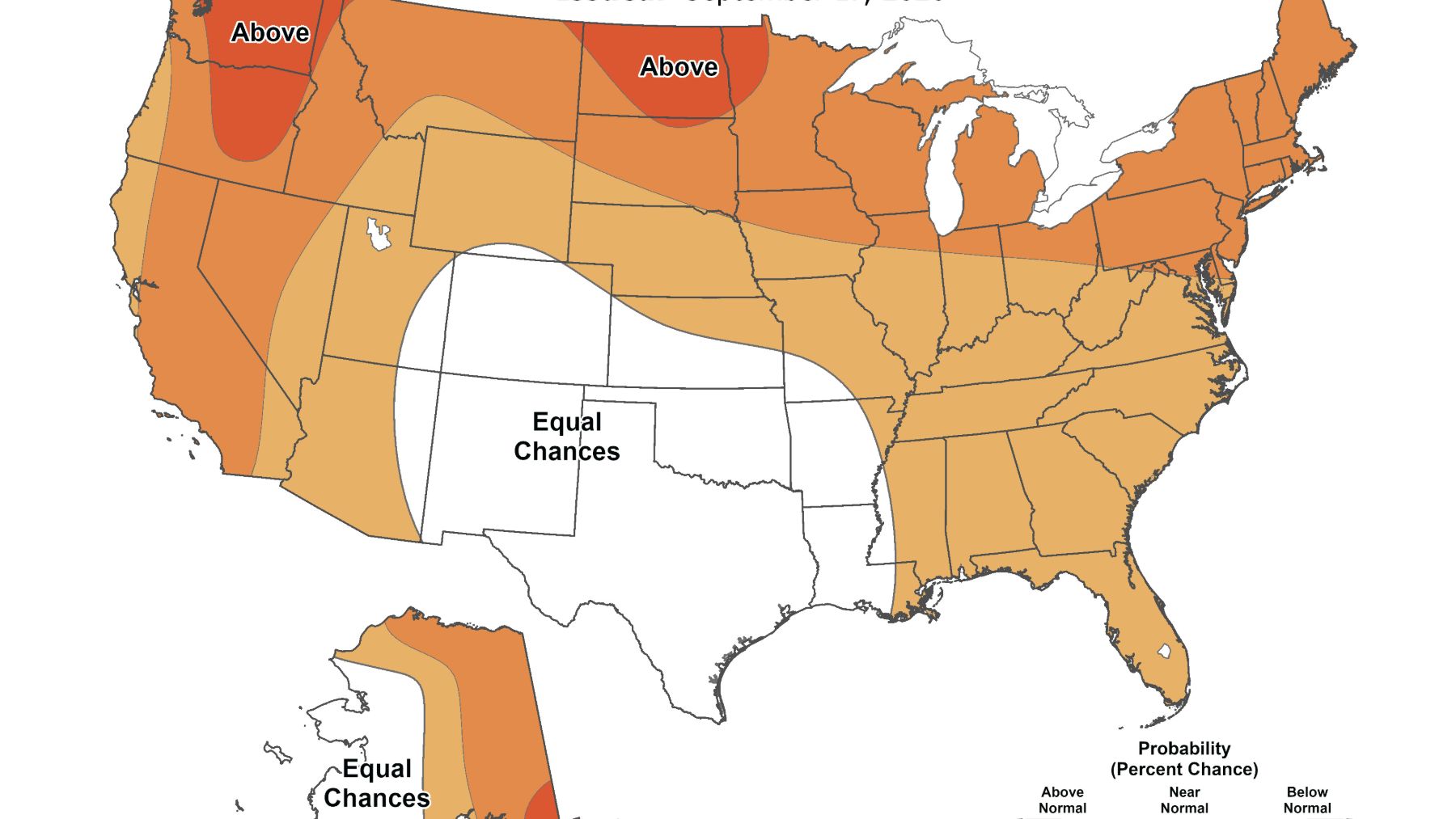
With that backdrop, the NOAA Climate Prediction Center (CPC) forecasts for October-December 2026 above-normal temperatures across much of the country and more rainfall in a swath extending from Southern California to the Southeast and the mid-Atlantic coast.
A 75% Chance of a Historic Episode
The CPC’s assessment of September 10 states: “During the October-December 2026 season, there is a 75% probability of a historic episode that would surpass the intensity of earlier El Niño episodes dating back to 1950.” The bar is set at a quarterly value of 2.5°C or more in the Niño-3.4 Relative Oceanic Niño Index (RONI).
In the August 13 assessment, that same probability was 69%. The CPC also places above 90% the probability that El Niño will be very strong during autumn and winter 2026-2027.
“The odds that it will become the strongest episode on record for the October-December season (as measured by the 3-month average of the Oceanic Niño Index) are already 75%,” wrote that same day Rebecca Lindsey, editor of the El Niño blog now published on Climate.us. According to Lindsey, there is also a 100% probability that the phenomenon will continue at least through the December-February season.
The explanation for such confidence came from Emily Becker, a researcher at the University of Miami and the scientific lead of the blog. The ocean and the atmosphere push the system in the same direction and, as Lindsey summarizes, “once both are strongly synchronized, their combined impulse is practically impossible to interrupt on seasonal scales.”
RONI Dampens Warming Across the Rest of the Tropics
For decades, the strength of El Niño has been measured by the sea-surface temperature anomaly in the Niño-3.4 region, in the central-eastern tropical Pacific. The problem is that tropical oceans have warmed collectively, and that distorts comparisons with past episodes.
That is why NOAA adopted, in early 2026, a relative index, which is the usual anomaly minus the mean anomaly of all tropical oceans. “What really matters for El Niño and La Niña is how much warmer or cooler the central tropical Pacific is compared with the rest of the tropical oceans,” Becker wrote on August 27.
With that standard, the relative Niño-3.4 index for July 2026 ranked second in the historical record, behind 1997, while the traditional index occupied first place. “Doing science in real time is hard, and the Niño-3.4 relative index is certainly imperfect,” Becker acknowledged, though she sees it as a major step toward separating what is truly El Niño from climate change.
Marc Alessi, a climate scientist with the Union of Concerned Scientists (UCS), made the same comparison in an article dated October 1. With the traditional index, he wrote, “we are already observing the strongest El Niño on record,” but with the RONI the 2015 and 1982 episodes are still stronger and 2026 ranks as the third strongest, though it is the strongest for these early-October dates.
More Than a 50% Chance of Heat in North Dakota and Alaska
The seasonal forecast, released on September 17, favors above-normal temperatures in much of Alaska, in most of the land west of the Rockies, in nearly all areas east of the Mississippi, and in the central-northern states between them. The highest chances, above 50%, are in Southeast Alaska, the northern Great Basin, and the vicinity of North Dakota and northwest Minnesota.
Between the Southern Rockies and the lower Mississippi Valley, sweeping through the Southern Plains, the map shows “equal odds” because signals are, according to the CPC, “weak or contradictory.”
All this occurs with a central tropical Pacific that, as Becker reminded, is already at record temperatures, although not all that warmth is due to El Niño.
Up to a 60-70% Chance of Rain in the Southeast
The wet signal stretches from the southern half of California, through the Four Corners region and the Great Plains, to the Mississippi and Tennessee valleys, the Southeast and the mid-Atlantic coast. According to the CPC, the maximum probabilities of rainfall above normal “range between 60 and 70% in parts of the Southeast,” something it regards as “reasonable given the current and projected intensity of El Niño.”
The interior of the Northwest and parts of the Great Lakes region lean toward a somewhat drier quarter, though the CPC calls those signals modest.
According to the CPC, that wet signal is largely tied to the mid-level position of the subtropical jet stream, a belt of fast winds high up, and the average path of storms. Alessi explains it this way: the jet shifts and allows “more moisture to be carried inland and more rainfall to be recorded in parts of the southern United States.”
Lindsey reminds on her blog that El Niño also influences atmospheric rivers, which can either end a drought or overwhelm dams.
For winter, the CPC raises the probability of rainfall above normal to 70-80% in South Georgia and North Florida, and to 50-60% near the California coast between December and April.
A 60% Is a Probability, Not 60% More Rain
These maps split the quarter into three categories (above normal, near normal, or below normal), and with no signal each would have a one-third probability. A 60% means the quarter is more likely to end up in the wet category, but it does not indicate how many inches will fall or how many days it will rain.
The “equal odds” scenario does not announce a normal quarter either; rather, the available tools do not permit favoring any of the three options.
California Prepares for Floods
California has already declared a state of emergency over El Niño. As Alessi quotes, the declaration orders state agencies “to begin protecting vulnerable communities, preparing roads and critical infrastructure, stocking emergency supplies, and helping local partners to reduce flood, landslide, and coastal risks.”
“This Super El Niño will undoubtedly have a significant impact on the southwestern United States this winter,” wrote the researcher, who mentions record sea levels, coastal erosion and sudden floods.
Outside the United States, Alessi notes that El Niño tends to bring drought to Indonesia, the Caribbean, Mozambique or Botswana, a list to which he adds the threat it poses to the Amazon.
A Stronger Niño Does Not Guarantee Impacts
The CPC remains cautious about what to expect. “With an event of this magnitude, the chances of suffering impacts in line with El Niño are higher, but not guaranteed,” it writes in its seasonal forecast.
There are two factors that make this case different, according to the bulletin. The three largest episodes since 1950—the 1982-83, 1997-98 and 2015-16 events—coincided with a positive phase of the Pacific Decadal Oscillation, while now that phase is negative (-1.11 in August) and “may dampen” typical impacts in some areas. Also, the warm water typically present in the Gulf of Alaska has shifted west, which could allow somewhat cooler waters to influence parts of the West Coast.
The past also invites caution. Alessi notes that during the last Super El Niño, in 2015-2016, California experienced a winter that was somewhat drier than usual, and Becker emphasizes that even in the strongest episodes “there is always a lot of variability in winter weather.”
And 75% remains a forecast. According to the RONI data cited by Alessi, the 2026 El Niño has not yet surpassed the largest episodes on record, and the CPC revises its diagnosis every month. A three-month average can hide weeks that vary greatly, and for day-to-day forecasts, local forecasts still rule.
The seasonal forecast was released on September 17, 2026 on the NOAA Climate Prediction Center website, signed by Anthony Artusa.
Image: NOAA / Climate Prediction Center